Please find below Mississippi River daily report for March 27, 2024
A Daily Publication of the New Orleans Board of Trade07:15 hrs. - 03/27/2024New information (Except for the Air Draft, River Stages, and Vessel Information) is highlighted in Green
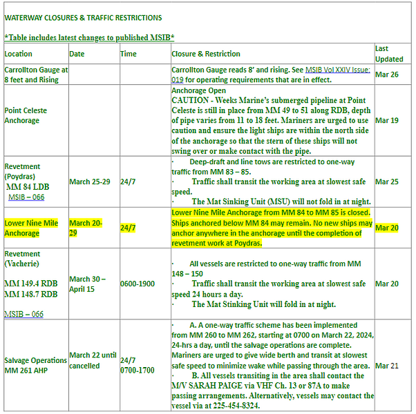
The Controlling Draft for Deep Draft Vessels is 50 Feet. There are two dredges working in Southwest Pass. 9 Mile Anchorage is closed due to Revetment Operations at Mile 84. Revetment Operations will be conducted until March 29th.
Pilot Recommendations: Bar Pilots: Recommended maximum loading draft: 50 Feet.
Crescent Pilots: Recommended maximum loading draft: 50 Feet.
NOBRA Pilots: Recommended loading draft is as follows: 50 feet from New Orleans to Mile 175 ; 47 Feet from Mile 175 - Mile 180; 45 feet from Mile 180 to Mile 234. Vessels with a draft of 41 feet or greater are required to transit the Baton Rouge Harbor (Mile 180 - Mile 234) during daylight hours only.
NOBRA Pilots - High Interest Vessels Vessels classified as HIGH Interest by the Coast Guard, A Federal Authority, Any State Authority, or the NOBRA Board of Directors, may require 2 pilots and be limited to daylight transit only along the NOBRA Route. Any customer of the NOBRA Pilots, docks, berths, moorings, agents, owner, or owner representative may petition the NOBRA Board of Directors to establish or remove the HIV classification. PER THE NOBRA PILOTS, A VESSEL ONLY REQUIRING A CREW CONTROL SECURITY PLAN (CCSP) BY THE COAST GUARD WILL NOT BE SUBJECT TO THE 2 PILOT RULE.
Federal Pilots: Recommended maximum loading draft:50 feet from the Sea Buoy to Mile 175; 45 feet from Mile 175 – Mile 232.4; and 40 feet from Mile 232.4 – Mile 233.8.Coast Guard Notices:
image.png77.9 KBCarrollton Gauge reads 8 feet and rising, the following operating requirements are in effect: 1. As per 33 CFR 161.65, the Governor Nicholls traffic light, Gretna Harbor traffic light, and Westwego traffic lights are energized. The Governor Nicholls Navigation Light and Gretna Navigation Light are extinguished.
2. As required by 33 CFR 165.810(b)(3), tows are prohibited from transiting VTS special areas by a vessel with insufficient power to permit ready maneuverability and safe handling (unable to maintain an average speed of at least 3 MPH (2.6 knots).
3. For all vessels operating in the Lower Mississippi River (LMR) below Mile Marker (MM) 233.9 Above Head of Passes (AHP), including South Pass and Southwest Pass, additional high-water requirements are found in Title 33 of the Code of Federal Regulations (CFR) 165.810.
4. All Deep Draft vessels to include Ocean-going Towing vessels should have three means to hold position unless moored to shore or a mooring buoy.
5. Downbound Ocean-going Towing vessels towing on the hawser should consult with the appropriate pilot association to determine the need for assist tug.
6. Towing vessels should review MSIB Vol XIX Issue 007 titled Towing Vessel Safety Advisory During High Water, issued 15 January 2019 for additional provisions.
Lower Mississippi River Bridges Air-Draft Calculations: The above clearances were calculated this morning using gauge readings provided by the Army Corps of Engineers. As a guide the pilots require at least an additional 3 feet of clearance for the Vessel's Air Draft. The individual pilot assigned to the vessel will make the final determination of the vessel's allowable clearance. Actual clearance should be verified when ordering pilot services.
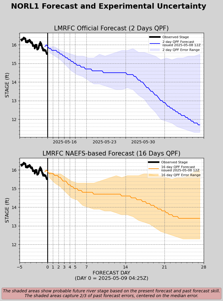
U.S. Corps of Engineers: VELOCITY READING (NEW ORLEANS) -2.6 Knots Mississippi River - Projection- Based off 48 Hours of Forecast Rainfall National Information: Marsec Level – 1
VESSELS SCHEDULED TO ARRIVE IN THE NEXT 24 HOURS:
VESSELS SCEHDULED TO DEPART IN THE NEXT 24 HOURS:
Weather / Marine Zone Forecast
Mississippi River - NOLA Projection- Based off 16 Days of Forecast Rainfall (Experimental)-
Disclaimer: For quality assurance purposes please note well that while the information contained in this website is regularly vetted for accuracy it is not intended to replace the local knowledge or expertise pertaining to port conditions of our marine operations personnel.
News Bulletin
Sign up to receive updates about port conditions, important notices, and other news.