Port Update
Boston, MA
January 24, 2025
Notices
BOSTON Harbor is at MARSEC Level 1
BOSTON CBP has noted the following:
Crew changes are being permitted. Offsigner flights need to be vetted by CBP in advance.
Shore leave is permitted.
Current Maximum Drafts at Oil Terminals
Current Maximum Drafts at Oil Terminals
***************************************
Citgo Braintree 34-09 Brakish Water
Global Chelsea 32-00 Salt Water
Global Revere 32-00 Salt Water
Global Eastern Ave. 35-00 Salt Water
Irving Revere 36-00 Salt Water
Sprague Deepwater 34-00 BERTH DEPTH, Salt Water
Sunoco East Boston 36-06 Salt Water
TRT Quincy 28-00 Salt Water
McArdle Bridge Update
*********************
The McArdle Bridge is operating on normal
on demand bridge openings for marine traffic.
Chelsea Street Bridge Update
****************************
The Chelsea Street Bridge is operating on normal
on demand bridge openings for marine traffic.
Fore River Bridge Update
************************
The Fore River Bridge is operating on normal
on demand bridge openings for marine traffic.
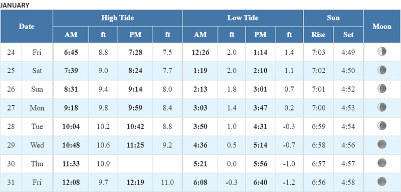
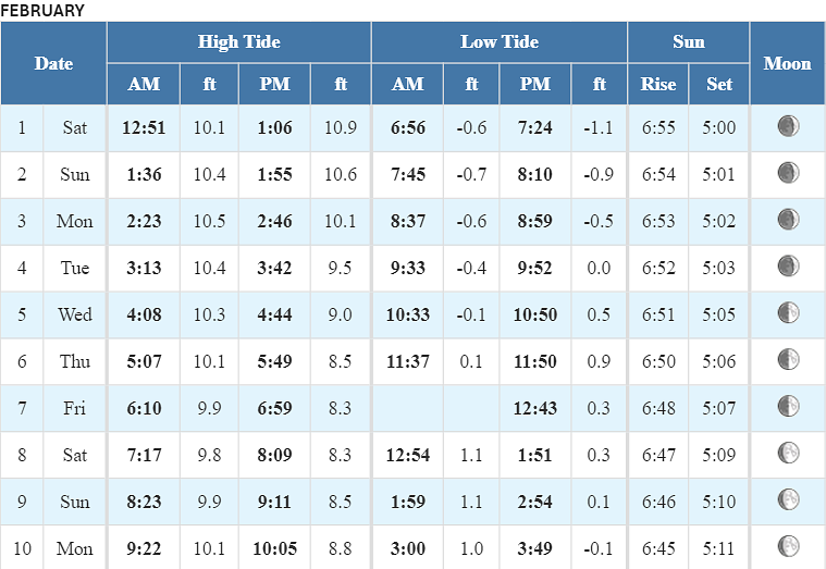
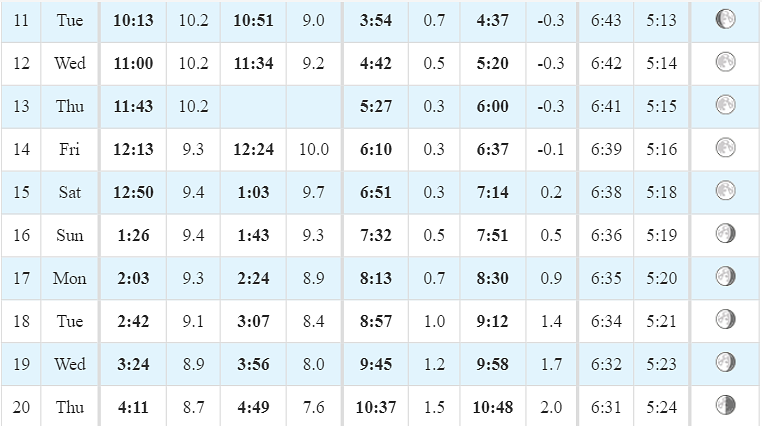
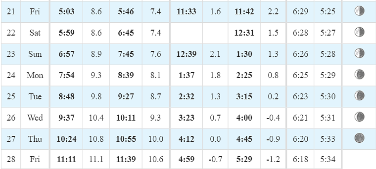
Tides / Currents
Weather / Marine Zone Forecast
Current weather
Sunny, 21° F
Feels Like 5° F
Today’s High 32° F
Wind, WNW 15 mph
Humidity 57%
Visibility 10.0 mi
Pressure 30.09 in
Plenty on sun.
Synopsis for Massachusetts and Rhode Island coastal waters:
Continued high pressure will be the dominant weather feature for the
next several days. But, an increasing pressure gradient will result
in increasing winds and building seas Saturday night into early next
week. Likely resulting in marine related headlines.
Coastal waters east of Ipswich Bay and the Stellwagen Bank National Marine Sanctuary:
.TODAY...W winds 10 to 15 kt with gusts up to 20 kt. Seas 2 to
3 ft. Wave Detail: W 3 ft at 4 seconds and SE 2 ft at 9 seconds.
.TONIGHT...NW winds 10 to 15 kt with gusts up to 20 kt. Seas 2 to
4 ft. Wave Detail: NW 3 ft at 4 seconds and SE 2 ft at 8 seconds.
.SAT...W winds around 15 kt with gusts up to 20 kt. Seas 2 to
4 ft. Wave Detail: NW 3 ft at 4 seconds and SE 2 ft at 8 seconds.
.SAT NIGHT...SW winds 15 to 20 kt with gusts up to 25 kt. Seas
3 to 5 ft. Wave Detail: SW 4 ft at 4 seconds and SE 2 ft at
9 seconds.
.SUN...W winds around 20 kt with gusts up to 30 kt. Seas 3 to
5 ft. Wave Detail: SW 4 ft at 4 seconds and SE 1 foot at
10 seconds.
.SUN NIGHT...W winds 15 to 20 kt with gusts up to 30 kt. Seas
4 to 6 ft. Wave Detail: W 4 ft at 5 seconds and SE 1 foot at
9 seconds.
.MON...SW winds 20 to 25 kt with gusts up to 30 kt. Seas 4 to
6 ft.
.MON NIGHT AND TUE...SW winds 20 to 25 kt with gusts up to 35 kt.
Seas 5 to 8 ft.
.TUE NIGHT...W winds 20 to 25 kt with gusts up to 30 kt. Seas
5 to 7 ft. A chance of light freezing spray.
Seas are reported as significant wave height, which is the
average of the highest third of the waves. Individual wave
heights may be more than twice the significant wave height.
If you would like updates for all OR other USA ports, the easiest method for reviewing our daily port updates is by visiting:
Subscribe / Unsubscribe to Daily Port Updates https://www.moranshipping.com/news/subscribers/new
MSA Useful Links
MSA Useful Links
****************
Army Corp of Engineers
Boston Harbor Pilot Association, LLC
NOAA
Chart viewer - handy tool for chart reference
Weather WEB Sites
Please visit our Boston Port site at:
Subscribe / Unsubscribe to Daily Port Updates https://www.moranshipping.com/news/subscribers/new
Daily Update Reference https://www.moranshipping.com/news/bulletins


