Port Update
Boston, MA
January 28, 2025
Notices
...GALE WARNING IN EFFECT UNTIL 7 PM EST THIS EVENING...
BOSTON Harbor is at MARSEC Level 1
BOSTON CBP has noted the following:
Crew changes are being permitted. Offsigner flights need to be vetted by CBP in advance.
Shore leave is permitted.
Current Maximum Drafts at Oil Terminals
Current Maximum Drafts at Oil Terminals
***************************************
Citgo Braintree 34-09 Brakish Water
Global Chelsea 32-00 Salt Water
Global Revere 32-00 Salt Water
Global Eastern Ave. 35-00 Salt Water
Irving Revere 36-00 Salt Water
Sprague Deepwater 34-00 BERTH DEPTH, Salt Water
Sunoco East Boston 36-06 Salt Water
TRT Quincy 28-00 Salt Water
McArdle Bridge Update
*********************
The McArdle Bridge is operating on normal
on demand bridge openings for marine traffic.
Chelsea Street Bridge Update
****************************
The Chelsea Street Bridge is operating on normal
on demand bridge openings for marine traffic.
Fore River Bridge Update
************************
The Fore River Bridge is operating on normal
on demand bridge openings for marine traffic.
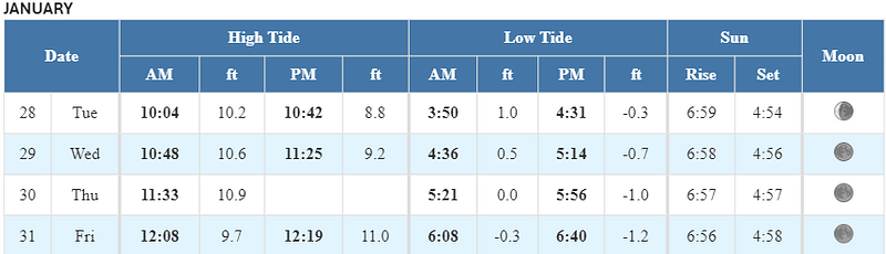
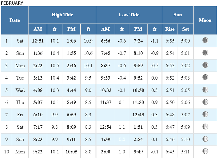
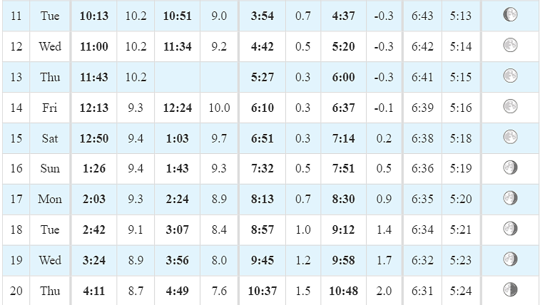
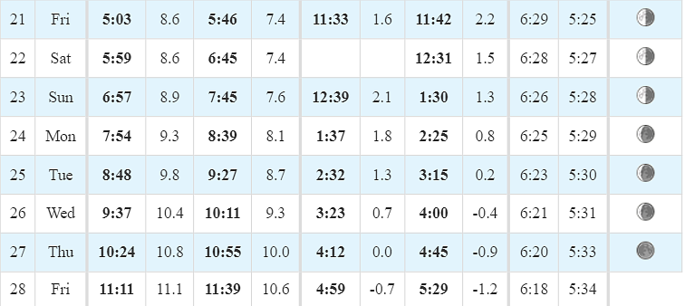
Tides / Currents
Weather / Marine Zone Forecast
Current weather
Partly cloudy, 36° F
Feels Like 21° F
Today’s High 38° F
Wind, WSW 20 mph
Humidity 38%
Visibility 10.0 mi
Pressure 29.35 in
Mostly cloudy and windy.
Synopsis for Massachusetts and Rhode Island coastal waters:
A strong cold front will cross the waters today, bringing WSW gales.
A quick moving low pres tracking from the Gt Lakes into New England
on Wed will be followed by gusty NW winds, bringing a brief shot of
arctic air and freezing spray Wed night and Thu. Low pres may track
to the south of the coastal waters Fri with gusty SW winds. A period
of gusty N-NW winds is possible Sat as the system pulls away.
Coastal waters east of Ipswich Bay and the Stellwagen Bank National Marine Sanctuary:
...GALE WARNING IN EFFECT UNTIL 7 PM EST THIS EVENING...
.TODAY...W winds 25 to 30 kt with gusts up to 40 kt. Seas 5 to
7 ft. Wave Detail: W 7 ft at 5 seconds and SE 2 ft at 7 seconds.
Light freezing spray likely this afternoon.
.TONIGHT...W winds 20 to 25 kt with gusts up to 30 kt, becoming
SW 10 to 15 kt with gusts up to 20 kt after midnight. Seas 4 to
6 ft, subsiding to 2 to 4 ft after midnight. Wave Detail: W 5 ft
at 5 seconds and SE 1 foot at 9 seconds, becoming SW 3 ft at
5 seconds and E 1 foot at 9 seconds. Light freezing spray likely
in the evening. Snow likely after midnight with vsby 1 to 3 NM.
.WED...SW winds 15 to 20 kt, becoming NW 10 to 15 kt in the
afternoon. Gusts up to 30 kt. Seas 2 to 4 ft. Wave Detail: SW
3 ft at 4 seconds and SE 1 foot at 10 seconds. Snow likely in the
morning with vsby 1 to 3 NM.
.WED NIGHT...NW winds 25 to 30 kt with gusts up to 35 kt. Seas
4 to 6 ft, building to 5 to 8 ft after midnight. Wave Detail: NW
5 ft at 4 seconds and SE 1 foot at 10 seconds, becoming NW 8 ft
at 6 seconds and SE 1 foot at 10 seconds. A chance of light
freezing spray after midnight.
.THU...NW winds 25 to 30 kt, becoming W 15 to 20 kt in the
afternoon. Seas 5 to 7 ft. Wave Detail: NW 7 ft at 6 seconds and
E 1 foot at 10 seconds. A chance of light freezing spray.
.THU NIGHT...SW winds 15 to 20 kt with gusts up to 30 kt. Seas
3 to 5 ft. Wave Detail: W 4 ft at 5 seconds and NE 1 foot at
8 seconds.
.FRI...SW winds 15 to 20 kt with gusts up to 30 kt. Seas 3 to
5 ft. A chance of rain.
.FRI NIGHT...NW winds 15 to 20 kt with gusts up to 25 kt. Seas
3 to 5 ft. A chance of rain and snow.
.SAT...N winds around 20 kt with gusts up to 25 kt. Seas 5 to
7 ft. A chance of light freezing spray. A chance of snow.
.SAT NIGHT...N winds 15 to 20 kt with gusts up to 25 kt. Seas
4 to 6 ft. A chance of light freezing spray.
Seas are reported as significant wave height, which is the
average of the highest third of the waves. Individual wave
heights may be more than twice the significant wave height.
If you would like updates for all OR other USA ports, the easiest method for reviewing our daily port updates is by visiting:
Subscribe / Unsubscribe to Daily Port Updates https://www.moranshipping.com/news/subscribers/new
MSA Useful Links
MSA Useful Links
****************
Army Corp of Engineers
Boston Harbor Pilot Association, LLC
NOAA
Chart viewer - handy tool for chart reference
Weather WEB Sites
Please visit our Boston Port site at:
Subscribe / Unsubscribe to Daily Port Updates https://www.moranshipping.com/news/subscribers/new
Daily Update Reference https://www.moranshipping.com/news/bulletins


