Port Update
RI / Southern Massachusetts
July 11, 2024
Notices
Homeland Security Advisory System
********************************************************************************
The National Homeland Security Advisory System is at Yellow (MARSEC Level I), or an elevated level of threat for the Port of Providence
Local Time Zone
********************************************************************************
The Port of Providence and Narragansett Bay are currently utilizing Eastern Standard Time (GMT -5)
Current maximum drafts at local terminals in feet:
Current maximum drafts at local terminals in feet:
Davisville: 32-00
Provport: 38-00
Hudson: 27-06
ExxonMobil: 38-00
Shell: 40-00
Sprague Providence: 32-00 (Flood tide restricted for berthing)
Sprague East Providence: 32-06 (Daylight & flood tide restricted for berthing)
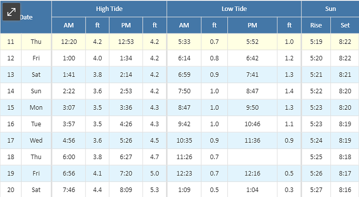
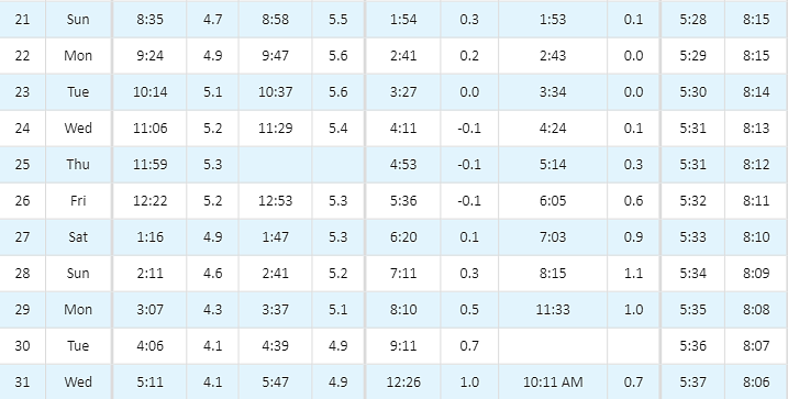
Tides / Currents
Weather / Marine Zone Forecast
Providence, RI Weather
********************************************************************************
Tonight: A slight chance of showers after 1am. Partly cloudy, with a low around 72. Southwest wind 5 to 14 mph. Chance of precipitation is 20%.
Friday: A chance of showers and thunderstorms. Partly sunny, with a high near 85. Southwest wind 7 to 14 mph. Chance of precipitation is 40%. New rainfall amounts of less than a tenth of an inch, except higher amounts possible in thunderstorms.
Friday Night: A chance of showers, mainly after 4am. Mostly cloudy, with a low around 73. South wind 7 to 9 mph. Chance of precipitation is 30%. New precipitation amounts between a tenth and quarter of an inch possible.
Saturday: A chance of showers and thunderstorms before 8am, then showers likely between 8am and 11am, then showers likely and possibly a thunderstorm after 11am. Mostly cloudy, with a high near 80. Southwest wind 7 to 9 mph. Chance of precipitation is 70%. New rainfall amounts between a half and three quarters of an inch possible.
Saturday Night: A chance of showers, mainly before 8pm. Mostly cloudy, with a low around 70. Southwest wind around 6 mph becoming calm in the evening. Chance of precipitation is 30%.
Sunday: Sunny, with a high near 90. Calm wind becoming west around 6 mph in the afternoon.
Sunday Night: Mostly clear, with a low around 71. Southwest wind around 6 mph.
Monday: Sunny, with a high near 92. Southwest wind 5 to 10 mph.
Monday Night: Partly cloudy, with a low around 71. Southwest wind 6 to 8 mph.
Tuesday: Mostly sunny, with a high near 91. Southwest wind 6 to 11 mph.
Tuesday Night: Partly cloudy, with a low around 73. Southwest wind 6 to 8 mph.
Wednesday: A chance of showers. Mostly sunny, with a high near 91. Southwest wind 6 to 11 mph. Chance of precipitation is 30%.
Wednesday Night: A chance of showers. Mostly cloudy, with a low around 68. Southwest wind around 7 mph. Chance of precipitation is 40%.
Thursday: A chance of showers. Partly sunny, with a high near 81. West wind 6 to 8 mph. Chance of precipitation is 40%.
Marine Forecast
********************************************************************************
Narragansett Bay:
Tonight: SW winds 10 to 15 kt, diminishing to 5 to 10 kt after midnight. Gusts up to 25 kt. Waves 3 to 5 ft. A slight chance of showers this evening, then a chance of showers after midnight with vsby 1 to 3 nm.
Fri: SW winds 10 to 15 kt with gusts up to 20 kt. Waves 2 to 4 ft. A chance of showers.
Fri Night: SW winds 10 to 15 kt. Gusts up to 20 kt in the evening. Waves 2 to 4 ft. A chance of showers after midnight.
Sat: SW winds 5 to 10 kt. Waves 2 to 3 ft. Showers likely. Vsby 1 to 3 nm.
Sat Night: SW winds 5 to 10 kt. Waves 2 to 3 ft. A chance of showers in the evening.
Sun And Sun Night: SW winds 5 to 10 kt. Waves 2 to 3 ft.
Mon Through Tue Night: SW winds 10 to 15 kt with gusts up to 20 kt. Waves 2 to 4 ft.
********************************************************************************
Rhode Island Sound:
Tonight: SW winds 15 to 20 kt, diminishing to 10 to 15 kt after midnight. Gusts up to 25 kt. Seas 4 to 6 ft. Wave detail: S 6 ft at 8 seconds and SW 1 foot at 3 seconds. A chance of showers. Isolated tstms after midnight. Vsby 1 to 3 nm.
Fri: SW winds 10 to 15 kt with gusts up to 20 kt. Seas 4 to 5 ft. Wave detail: S 5 ft at 8 seconds and SW 1 foot at 3 seconds. A chance of showers in the morning.
Fri Night: SW winds 10 to 15 kt. Gusts up to 20 kt in the evening. Seas 3 to 4 ft. Wave detail: S 4 ft at 7 seconds and SW 1 foot at 3 seconds. A chance of showers after midnight with vsby 1 to 3 nm.
Sat: SW winds 10 to 15 kt. Seas 2 to 4 ft. Wave detail: S 4 ft at 7 seconds. Showers likely. Vsby 1 to 3 nm.
Sat Night: SW winds 5 to 10 kt. Seas 3 to 4 ft. Wave detail: S 4 ft at 8 seconds. A chance of showers in the evening.
Sun And Sun Night: SW winds 5 to 10 kt. Seas 2 to 4 ft. Wave detail: S 4 ft at 8 seconds.
Mon Through Tue Night: SW winds 10 to 15 kt with gusts up to 20 kt. Seas 2 to 4 ft.
********************************************************************************
Buzzards Bay:
Tonight: SW winds 15 to 20 kt, diminishing to 10 to 15 kt after midnight. Gusts up to 30 kt. Seas 3 to 5 ft. Wave detail: SW 4 ft at 7 seconds and SW 3 ft at 4 seconds. A chance of showers. Vsby 1 to 3 nm after midnight.
Fri: SW winds 10 to 15 kt with gusts up to 25 kt. Seas 2 to 3 ft. Wave detail: SW 2 ft at 3 seconds and S 2 ft at 8 seconds. A chance of showers in the morning.
Fri Night: SW winds 10 to 15 kt. Gusts up to 20 kt in the evening. Seas 2 to 3 ft. Wave detail: SW 2 ft at 3 seconds and S 2 ft at 7 seconds. A chance of showers after midnight.
Sat: SW winds 10 to 15 kt. Gusts up to 20 kt in the afternoon. Seas 2 to 3 ft. Wave detail: S 2 ft at 7 seconds and SW 1 foot at 3 seconds. Showers likely. Vsby 1 to 3 nm.
Sat Night: SW winds 5 to 10 kt. Seas 2 to 3 ft. Wave detail: SW 3 ft at 8 seconds and SW 1 foot at 3 seconds. A chance of showers in the evening.
Sun And Sun Night: SW winds 5 to 10 kt. Seas around 2 ft. Wave detail: SW 2 ft at 8 seconds and W 1 foot at 3 seconds.
Mon Through Tue Night: SW winds 10 to 15 kt with gusts up to 20 kt. Seas 2 to 3 ft.
********************************************************************************
Cape Cod Bay:
Tonight: SW winds 15 to 20 kt, diminishing to 10 to 15 kt after midnight. Gusts up to 25 kt. Seas 2 to 4 ft. Wave detail: SW 2 ft at 3 seconds and S 2 ft at 8 seconds. A slight chance of showers this evening, then a chance of showers after midnight with vsby 1 to 3 nm.
Fri: SW winds 10 to 15 kt with gusts up to 25 kt. Seas 2 to 3 ft. Wave detail: SW 2 ft at 3 seconds and S 2 ft at 8 seconds. A chance of showers in the morning.
Fri Night: SW winds 10 to 15 kt. Gusts up to 20 kt in the evening. Seas 2 to 3 ft. Wave detail: SW 2 ft at 3 seconds and S 2 ft at 7 seconds.
Sat: SW winds around 10 kt. Seas around 2 ft. Wave detail: S 2 ft at 7 seconds and SW 1 foot at 2 seconds. A chance of showers in the morning, then showers likely in the afternoon. Vsby 1 to 3 nm.
Sat Night: SW winds 5 to 10 kt. Seas around 2 ft. Wave detail: S 2 ft at 8 seconds and SW 1 foot at 2 seconds. A chance of showers in the evening.
Sun And Sun Night: SW winds 5 to 10 kt. Seas 1 foot or less. Wave detail: W 1 foot at 2 seconds and S 1 foot at 8 seconds.
Mon Through Tue Night: SW winds 10 to 15 kt with gusts up to 20 kt. Seas around 2 ft.
Port / Terminal Restrictions
Cape Cod Canal Draft Restriction
********************************************************************************
The US Army Corp of Engineers has advised that the current maximum air draft for Cape Cod Canal transits remains at 135 feet. Max draft in the canal is currently 30 feet. Vessels with drafts over 26 feet will need a tide window for transit
Cape Cod Canal Transit Restriction
********************************************************************************
None at the moment
COVID 19 Guidance
********************************************************************************
COVID 19 is providing its own unique challenges, requiring all to stay extra vigilant on changing port call conditions and regulations. If you would like updates for all USA ports, the easiest method for reviewing our daily port updates is by visiting: http://ports.moranshipping.com/default.aspx
Please visit our Providence Port site at: http://ri.ports.moranshipping.com/default.aspx
Please visit our Providence Port site at: http://ri.ports.moranshipping.com/default.aspx


