Port Update
RI / Southern Massachusetts
January 08, 2025
Notices
Homeland Security Advisory System
********************************************************************************
The National Homeland Security Advisory System is at Yellow (MARSEC Level I), or an elevated level of threat for the Port of Providence
Local Time Zone
********************************************************************************
The Port of Providence and Narragansett Bay are currently utilizing Eastern Standard Time (GMT -5)
Current maximum drafts at local terminals in feet:
Current maximum drafts at local terminals in feet:
Davisville: 32-00
Provport: 38-00
Hudson: 27-06
ExxonMobil: 38-00
Shell: 40-00
Sprague Providence: 32-00 (Flood tide restricted for berthing)
Sprague East Providence: 32-06 (Daylight & flood tide restricted for berthing)
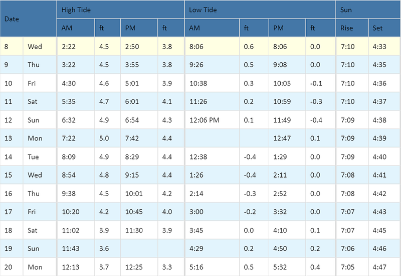
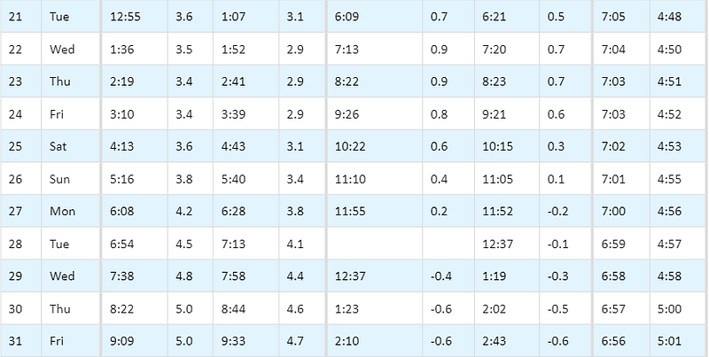
Tides / Currents
Weather / Marine Zone Forecast
Providence, RI Weather
********************************************************************************
his Afternoon: Mostly sunny, with a high near 26. West wind around 18 mph, with gusts as high as 37 mph.
Tonight: Partly cloudy, with a low around 15. Northwest wind 11 to 15 mph, with gusts as high as 26 mph.
Thursday: Mostly sunny, with a high near 29. Northwest wind 13 to 15 mph, with gusts as high as 32 mph.
Thursday Night: Mostly clear, with a low around 22. Northwest wind 9 to 14 mph, with gusts as high as 31 mph.
Friday: Sunny, with a high near 38. Northwest wind 6 to 10 mph.
Friday Night: A slight chance of snow after 4am. Mostly cloudy, with a low around 24. Light northwest wind. Chance of precipitation is 20%.
Saturday: A chance of snow. Mostly cloudy, with a high near 33. Calm wind becoming northwest around 6 mph in the afternoon. Chance of precipitation is 50%.
Saturday Night: Mostly cloudy, with a low around 24. Northwest wind around 7 mph.
Sunday: Sunny, with a high near 38. Northwest wind 6 to 8 mph.
Sunday Night: Mostly clear, with a low around 20. Light northwest wind.
Monday: Mostly sunny, with a high near 36. Calm wind becoming west around 6 mph in the morning.
Monday Night: Partly cloudy, with a low around 21. Light northwest wind.
Tuesday: Mostly sunny, with a high near 35. Northwest wind 5 to 9 mph.
Marine Forecast
********************************************************************************
Narragansett Bay:
This Afternoon: W winds 20 to 25 kt with gusts up to 30 kt. Waves around 3 ft, except 4 to 6 ft at the bay entrance. Light freezing spray.
Tonight: NW winds 15 to 20 kt with gusts up to 30 kt. Waves around 3 ft, except 4 to 6 ft at the bay entrance. Light freezing spray.
Thu: NW winds 15 to 20 kt with gusts up to 30 kt. Waves around 3 ft. Light freezing spray.
Thu Night: NW winds 15 to 20 kt. Gusts up to 35 kt, decreasing to 25 kt after midnight. Waves 2 to 3 ft. A chance of light freezing spray in the evening.
Fri And Fri Night: NW winds 10 to 15 kt with gusts up to 20 kt. Waves 2 to 3 ft.
Sat And Sat Night: NW winds 5 to 10 kt, increasing to 10 to 15 kt with gusts up to 20 kt. Waves 1 foot or less, then 2 to 3 ft. A chance of snow. Vsby 1 to 3 nm.
Sun And Sun Night: NW winds 10 to 15 kt with gusts up to 20 kt, diminishing to 5 to 10 kt. Waves 2 to 3 ft.
********************************************************************************
Rhode Island Sound:
This Afternoon: W winds 25 to 30 kt with gusts up to 35 kt. Seas 5 to 7 ft. Wave detail: W 7 ft at 6 seconds and S 1 foot at 10 seconds. Light freezing spray.
Tonight: NW winds 25 to 30 kt with gusts up to 35 kt. Seas 5 to 7 ft. Wave detail: W 7 ft at 6 seconds and S 1 foot at 12 seconds. Light freezing spray.
Thu: NW winds 20 to 25 kt with gusts up to 35 kt. Seas 3 to 5 ft. Wave detail: NW 5 ft at 6 seconds. Light freezing spray.
Thu Night: NW winds 20 to 25 kt. Gusts up to 35 kt in the evening. Seas 3 to 5 ft. Wave detail: NW 5 ft at 5 seconds.
Fri: NW winds 15 to 20 kt, diminishing to 10 to 15 kt in the afternoon. Gusts up to 25 kt. Seas 3 to 4 ft, subsiding to 2 ft in the afternoon. Wave detail: N 4 ft at 5 seconds, becoming N 2 ft at 5 seconds.
Fri Night: NW winds 10 to 15 kt, diminishing to 5 to 10 kt after midnight. Seas around 2 ft in the evening, then 1 foot or less. Wave detail: N 2 ft at 5 seconds, becoming NW 1 foot at 5 seconds and E 1 foot at 17 seconds. A chance of snow after midnight.
Sat: NW winds 10 to 15 kt. Seas around 2 ft. Snow likely. Vsby 1 to 3 nm.
Sat Night: NW winds 15 to 20 kt with gusts up to 25 kt. Seas 2 to 3 ft. A chance of snow.
Sun And Sun Night: NW winds 15 to 20 kt, diminishing to 10 to 15 kt. Seas 2 to 3 ft.
********************************************************************************
Buzzards Bay:
This Afternoon: W winds 20 to 25 kt with gusts up to 30 kt. Seas 4 to 5 ft. Wave detail: W 5 ft at 6 seconds and N 1 foot at 7 seconds. Light freezing spray.
Tonight: NW winds 20 to 25 kt with gusts up to 30 kt. Seas 4 to 5 ft. Wave detail: W 4 ft at 6 seconds and N 1 foot at 7 seconds. Light freezing spray.
Thu: NW winds 15 to 20 kt with gusts up to 30 kt. Seas 3 to 4 ft. Wave detail: NW 4 ft at 6 seconds. Light freezing spray.
Thu Night: NW winds 20 to 25 kt. Gusts up to 35 kt in the evening. Seas 3 to 5 ft. Wave detail: N 3 ft at 6 seconds. A chance of light freezing spray after midnight.
Fri And Fri Night: NW winds 15 to 20 kt with gusts up to 25 kt. Seas 2 to 4 ft. Wave detail: N 3 ft at 5 seconds.
Sat: NW winds 10 to 15 kt. Seas 1 foot or less. Wave detail: SW 1 foot at 5 seconds and NE 1 foot at 6 seconds. Snow likely. Vsby 1 nm or less.
Sat Night: NW winds 15 to 20 kt. Seas around 2 ft. A chance of snow.
Sun And Sun Night: NW winds 10 to 15 kt with gusts up to 20 kt, diminishing to 5 to 10 kt. Seas 2 to 3 ft.
********************************************************************************
Cape Cod Bay:
This Afternoon: W winds 25 to 30 kt. Seas 5 to 6 ft. Wave detail: N 5 ft at 7 seconds and SE 1 foot at 12 seconds. Light freezing spray.
Tonight: NW winds 25 to 30 kt. Seas 5 to 6 ft. Wave detail: N 6 ft at 7 seconds and SE 1 foot at 12 seconds. Light freezing spray.
Thu: NW winds 20 to 25 kt, increasing to 25 to 30 kt in the afternoon. Seas 4 to 5 ft. Wave detail: N 5 ft at 7 seconds. Light freezing spray.
Thu Night: NW winds 25 to 30 kt, diminishing to 20 to 25 kt after midnight. Seas 4 to 6 ft. Wave detail: N 6 ft at 7 seconds.
Fri: NW winds 20 to 25 kt, diminishing to 10 to 15 kt in the afternoon. Seas 3 to 5 ft. Wave detail: N 5 ft at 7 seconds.
Fri Night: NW winds 10 to 15 kt, diminishing to 5 to 10 kt after midnight. Seas 2 to 3 ft. Wave detail: N 3 ft at 7 seconds and E 1 foot at 15 seconds.
Sat: W winds 5 to 10 kt. Seas 1 foot or less. Snow likely with a chance of rain. Vsby 1 nm or less.
Sat Night: NW winds 15 to 20 kt with gusts up to 25 kt. Seas 2 to 4 ft. A chance of snow and rain. Vsby 1 to 3 nm.
Sun And Sun Night: NW winds 15 to 20 kt with gusts up to 25 kt, diminishing to around 10 kt. Seas 2 to 4 ft.
Port / Terminal Restrictions
Cape Cod Canal Draft Restriction
********************************************************************************
The US Army Corp of Engineers has advised that the current maximum air draft for Cape Cod Canal transits remains at 135 feet. Max draft in the canal is currently 30 feet. Vessels with drafts over 28 feet will need a tide window for transit
Cape Cod Canal Transit Restriction
********************************************************************************
None at the moment
COVID 19 Guidance
********************************************************************************
COVID 19 is providing its own unique challenges, requiring all to stay extra vigilant on changing port call conditions and regulations. If you would like updates for all USA ports, the easiest method for reviewing our daily port updates is by visiting: http://ports.moranshipping.com/default.aspx
Please visit our Providence Port site at: http://ri.ports.moranshipping.com/default.aspx
Please visit our Providence Port site at: http://ri.ports.moranshipping.com/default.aspx


