Port Alert
Connecticut / Long Island Sound
March 18, 2025
Notices
Two New Right Whale Slow Zones: SE of Atlantic City, NJ and SW of Nantucket, MA
Effective Through April 1 and April 2
On March 17, 2025, the Martha's Vineyard buoy operated by the Woods Hole Oceanographic Institution (WHOI) detected the presence of right whales southwest of Nantucket, MA. The right whale slow zone is in effect through April 1, 2025.
On March 18, 2025, the Atlantic City buoy operated by WHOI detected the presence of right whales southeast of Atlantic City, NJ. The right whale slow zone is in effect through April 2, 2025.
As a reminder, five additional Slow Zones are also currently in effect. Locations and effective dates are listed below.
Voluntary Right Whale "Slow Zone" Areas
Mariners are requested to avoid or transit at 10 knots or less inside the following Dynamic Management Areas (DMAs) and Acoustic Slow Zones where right whales have been detected. Please visit our website for more information.
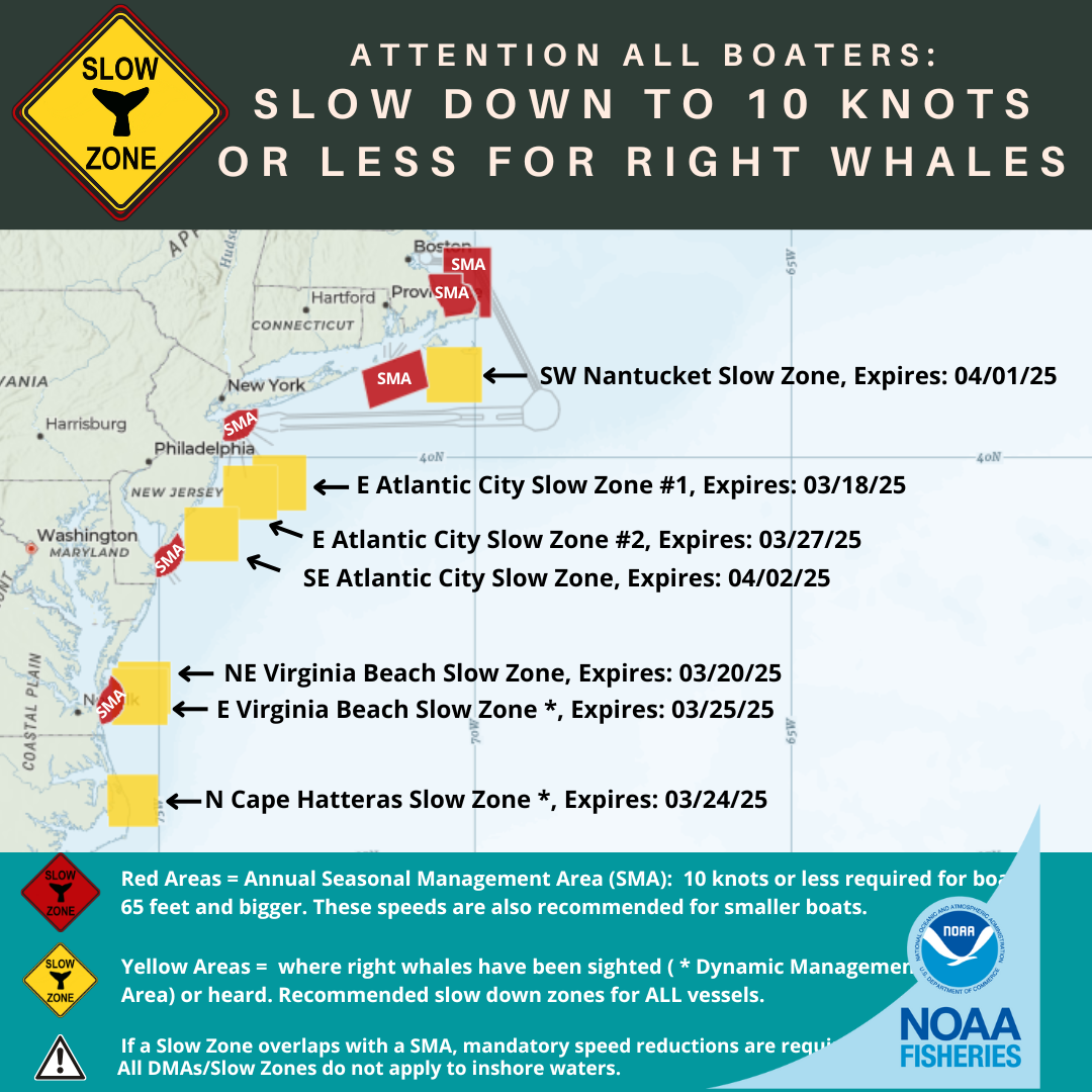
Southeast of Atlantic City, NJ Acoustic Slow Zone: Effective March 18 - April 2, 2025
Waters bounded by:
NORTHERN BOUNDARY: 39°25' N
SOUTHERN BOUNDARY: 38°44' N
EASTERN BOUNDARY: 73°44' W
WESTERN BOUNDARY: 73°36' W
Southwest of Nantucket Acoustic Slow Zone: Effective March 17 - April 1, 2025
Waters bounded by:
NORTHERN BOUNDARY: 41°20' N
SOUTHERN BOUNDARY: 40°40' N
EASTERN BOUNDARY: 69°53' W
WESTERN BOUNDARY: 70°36' W
East of Atlantic City, NJ Acoustic Slow Zone #2: Effective March 12 - 27, 2025
Waters bounded by:
NORTHERN BOUNDARY: 39°55' N
SOUTHERN BOUNDARY: 39°15' N
EASTERN BOUNDARY: 73°08' W
WESTERN BOUNDARY: 73°59' W
East of Virginia Beach, VA DMA Slow Zone: Effective March 10 - 25, 2025
Waters bounded by:
NORTHERN BOUNDARY: 37°24' N
SOUTHERN BOUNDARY: 36°41' N
EASTERN BOUNDARY: 74°51' W
WESTERN BOUNDARY: 75°44' W
North of Cape Hatteras, NC DMA Slow Zone: Effective March 9 - 24, 2025
Waters bounded by:
NORTHERN BOUNDARY: 36°03' N
SOUTHERN BOUNDARY: 35°23' N
EASTERN BOUNDARY: 75°01' W
WESTERN BOUNDARY: 75°49' W
Northeast of Virginia Beach, VA Acoustic Slow Zone: Effective March 5 - 20, 2025
Waters bounded by:
NORTHERN BOUNDARY: 37°29' N
SOUTHERN BOUNDARY: 36°50' N
EASTERN BOUNDARY: 74°49' W
WESTERN BOUNDARY: 75°40' W
East of Atlantic City, NJ Acoustic Slow Zone #1: Effective March 3 - 18, 2025
Waters bounded by:
NORTHERN BOUNDARY: 40°01' N
SOUTHERN BOUNDARY: 39°21' N
EASTERN BOUNDARY: 72°40' W
WESTERN BOUNDARY: 73°32' W
Active Seasonal Management Areas (SMAs)
Mandatory speed restrictions of 10 knots or less (50 CFR 224.105) are in effect for most vessels 65 ft or longer in the following areas:
Mid-Atlantic U.S. SMAs (Nov 1 - Apr 30)
Southeast U.S. SMAs (Nov 15 - Apr 15)
Cape Cod Bay SMA (Jan 1 - May 15)
Off Race Point SMA (Mar 1 - Apr 30)
NOTE: From March 1-April 30, Massachusetts state law requires all vessels, regardless of size, to adhere to the 10 knot speed limit within the Cape Cod Bay SMA.
Give Right Whales Room
North Atlantic right whales are on the move along the Atlantic coast of the U.S. If seen, remember that approaching a right whale closer than 500 yards is a violation of federal law.
Right Whales in Trouble
Endangered North Atlantic right whales are approaching extinction. There are approximately 360 individuals remaining, including fewer than 70 reproductively active females. Human impacts continue to threaten the survival of this species.
In August 2017, NOAA Fisheries declared the increase in right whale mortalities an “Unusual Mortality Event,” which helps the agency direct additional scientific and financial resources to investigating, understanding, and reducing the mortalities in partnership with the Marine Mammal Stranding Network, Canada’s Department of Fisheries and Oceans, and outside experts from the scientific research community.
More Information
Download the Whale Alert app for iPad, iPhone, and Android for real time updates on Slow Zones, SMAs, and other right whale sightings.
Spread the Word!
All boaters from Maine to Virginia, or interested parties, can sign up for email or text notifications about the latest Right Whale Slow Zones. You can also follow us on Facebook (@NOAAFisheriesNEMA) and Twitter (@NOAAFish_GARFO) for announcements.
Questions?
New Phone Number for Text Message Alerts
For your awareness, starting May 13, NOAA Fisheries will be sending text message alerts from a new, toll-free phone number: (844) 548-2865. This will replace our current 468-311 number. Learn more about our text message service.


