Port Update
Boston, MA
April 14, 2025
Notices
BOSTON Harbor is at MARSEC Level 1
BOSTON CBP has noted the following:
Crew changes are being permitted. Offsigner flights need to be vetted by CBP in advance.
Shore leave is permitted.
Current Maximum Drafts at Oil Terminals
Current Maximum Drafts at Oil Terminals
***************************************
Citgo Braintree 34-09 Brakish Water
Global Chelsea 32-00 Salt Water
Global Revere 32-00 Salt Water
Global Eastern Ave. 35-00 Salt Water
Irving Revere 36-00 Salt Water
Sprague Deepwater 34-00 BERTH DEPTH, Salt Water
Sunoco East Boston 36-06 Salt Water
TRT Quincy 28-00 Salt Water
McArdle Bridge Update
*********************
The McArdle Bridge is operating on normal
on demand bridge openings for marine traffic.
Chelsea Street Bridge Update
****************************
The Chelsea Street Bridge is operating on normal
on demand bridge openings for marine traffic.
Fore River Bridge Update
************************
The Fore River Bridge is operating on normal
on demand bridge openings for marine traffic.
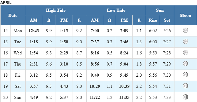
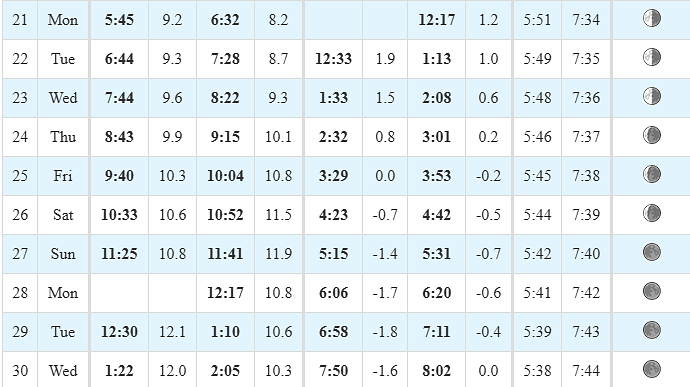
Tides / Currents
Weather / Marine Zone Forecast
Current weather
Sunny, 43° F
Feels Like 39° F
Today’s High 64° F
Wind, WNW 9 mph
Humidity 60%
Visibility 10.0 mi
Pressure 29.79 in
Sunny and warmer.
Synopsis for Massachusetts and Rhode Island coastal waters:
Drier weather returns to start the week, with unsettled weather
returning tonight into tomorrow. A strong cold front brings a period
of westerly winds tomorrow evening. Clearer conditions return Wed
into Fri. Rain returns for Sat with the passage of a warm front. Sun
may see more clearing with a cold frontal passage.
Coastal waters east of Ipswich Bay and the Stellwagen Bank National Marine Sanctuary:
...SMALL CRAFT ADVISORY IN EFFECT THROUGH THIS EVENING...
.TODAY...NW winds 10 to 15 kt, becoming W 5 to 10 kt this
afternoon. Gusts up to 25 kt. Seas 4 to 6 ft. Wave Detail: NE
5 ft at 7 seconds.
.TONIGHT...S winds 10 to 15 kt. Seas 2 to 4 ft. Wave Detail: NE
4 ft at 8 seconds and S 2 ft at 3 seconds. A chance of rain after
midnight.
.TUE...S winds 10 to 15 kt with gusts up to 20 kt. Seas 2 to
3 ft. Wave Detail: S 2 ft at 3 seconds and E 2 ft at 9 seconds. A
chance of rain in the morning, then scattered showers in the
afternoon.
.TUE NIGHT...SW winds 10 to 15 kt, becoming W 15 to 20 kt after
midnight. Gusts up to 25 kt. Seas 2 to 4 ft. Wave Detail: SW 3 ft
at 4 seconds and E 2 ft at 10 seconds. Scattered showers in the
evening.
.WED AND WED NIGHT...W winds 15 to 20 kt with gusts up to 25 kt.
Seas 3 to 5 ft. Wave Detail: W 3 ft at 4 seconds and SE 2 ft at
10 seconds.
.THU AND THU NIGHT...W winds 15 to 20 kt, becoming NW around
10 kt. Gusts up to 25 kt. Seas 2 to 4 ft. Wave Detail: W 3 ft at
4 seconds and SE 1 foot at 9 seconds.
.FRI...SW winds 10 to 15 kt with gusts up to 20 kt. Seas around
2 ft.
.FRI NIGHT...S winds 15 to 20 kt with gusts up to 25 kt. Seas
2 to 4 ft. A chance of showers.
Seas are reported as significant wave height, which is the
average of the highest third of the waves. Individual wave
heights may be more than twice the significant wave height.
If you would like updates for all OR other USA ports, the easiest method for reviewing our daily port updates is by visiting:
Subscribe / Unsubscribe to Daily Port Updates https://www.moranshipping.com/news/subscribers/new
MSA Useful Links
MSA Useful Links
****************
Army Corp of Engineers
Boston Harbor Pilot Association, LLC
NOAA
Chart viewer - handy tool for chart reference
Weather WEB Sites
Please visit our Boston Port site at:
Subscribe / Unsubscribe to Daily Port Updates https://www.moranshipping.com/news/subscribers/new
Daily Update Reference https://www.moranshipping.com/news/bulletins


