Please find below Mississippi River daily report for April 23, 2025
A Daily Publication of the New Orleans Board of Trade
06:50 hrs. - 04/23/2025
New information (Except for the Air Draft, River Stages, and Vessel Information) is highlighted in Green
General Information: The Controlling Draft for Deep Draft Vessels is 50 Feet.
There are three dredges working in Southwest Pass. The Corps has also started the process of contracting for a cutterhead dredge to work in Southwest Pass. At this time, the river has not reached the trigger points for opening the Bonnet Carre Anchorage. If the trigger points are reached, which could happen next week, the Corps has advised that the spillway would be operational for about 10 days.
Current High-Water Restrictions (Coast Guard):
Ocean going vessels must use tug escorts with adequate horsepower alongside while transiting above the I-10 Bridge to the dock, as well as departing the dock and transiting southbound past the I-10 Bridge.
Pilot Associations shall notify VTS LMR prior to oceangoing vessels transiting the area.
Only one ocean going vessel at a time will be allowed to be underway between the I-10 Bridge and the US-190 Bridge.
Ocean going vessels shall not anchor in the upper half mile of the Baton Rouge General Anchorage. The Pilot must notify VTS if it is necessary to anchor any vessel in the remainder of the anchorage.
Mooring/unmooring operations at all mid-stream transfer facilities and any berth that requires the use of a mooring boat along the NOBRA Pilot’s Route shall be restricted to daylight hours.
Bar Pilots High Water Restrictions in Place: Due to severe flocculation Pilots on station are recommending a transit time of 8 hours before to 2 hours after high tide for inbound ships with 38' or greater. Crescent Pilots High Water Restrictions in Place:
No vessel is to anchor in General Anchorage except in an emergency
No head down berthing (Special Service may be available in certain cases)
No stern first in Chalmette Slip (Special Service may be available in certain cases)
Vessels with draft of 30 feet or greater are prohibited from anchoring at 9 and12 Mile Anchorages.
The minimum distance between vessels at 9 and 12 Mile Anchorage shall be 1000 feet.
Midstream mooring restrictions enacted by line handling services concerning the safety of the mooring crew shall be observed by Crescent Pilots
Vessels at mid-stream moorings are required to maintain a pilot until it is determined, by the pilot onboard, that the vessel is secure and no longer requires pilot assistance.
Chalmette Slip - Vessels berthed at Sections “D” and “E” should be moved if another vessel must berth or sail form Sections “C” or “F”.
Projected High Water Restrictions: NOBRA Pilots: Carrolton Gauge – 16 Feet and Rising:
Mile 233 AHP to Mile 90.5 AHP southbound vessels will be daylight only.
Mile 166 AHP – Mile 233.2 – All vessels will be daylight only
Vessels anchoring in NOBRA’s area responsibility with a draft of 35 feet or greater must maintain a pilot on board while at anchor
Pilots dispatched to ensure a vessel remains stable at a safe berth shall serve no mor than six consecutive bridge hours
Pilot Recommendations: Bar Pilots: Recommended maximum loading draft: 50 Feet. Crescent Pilots: Recommended maximum loading draft: 50 Feet. NOBRA Pilots: Recommended loading draft is as follows: 50 feet from New Orleans to Mile 175 ; 47 Feet from Mile 175 - Mile 180; 45 feet from Mile 180 to Mile 234. Vessels with a draft of 41 feet or greater are required to transit the Baton Rouge Harbor (Mile 180 - Mile 234) during daylight hours only.
NOBRA Pilots - High Interest Vessels Vessels classified as HIGH Interest by the Coast Guard, A Federal Authority, Any State Authority, or the NOBRA Board of Directors, may require 2 pilots and be limited to daylight transit only along the NOBRA Route. Any customer of the NOBRA Pilots, docks, berths, moorings, agents, owner, or owner representative may petition the NOBRA Board of Directors to establish or remove the HIV classification. PER THE NOBRA PILOTS, A VESSEL ONLY REQUIRING A CREW CONTROL SECURITY PLAN (CCSP) BY THE COAST GUARD WILL NOT BE SUBJECT TO THE 2 PILOT RULE.
Federal Pilots: Recommended maximum loading draft:50 feet from the Sea Buoy to Mile 175; 45 feet from Mile 175 – Mile 232.4; and 40 feet from Mile 232.4 – Mile 233.8.
Coast Guard Notices: CARROLLTON GAUGE AT 15 FEET AND RISING: When the Carrollton Gauge reads 15 feet and rising, the following operating requirements will be in effect:
As per 33 CFR 165.810 (d) (2), vessels are prohibited from entering South Pass (from the Gulf) if the vessel has a speed of less than 10 miles per hour (MPH) (8.7 knots).
A VTS measure may be established prohibiting cargo operations in the anchorages without COTP permission between SWP and mile marker 167.5 AHP (bunkers and ship stores are exempt).
Vessels should be separated by 1000 feet in anchorages throughout the LMR when practicable.
High Water Facility / Barge Fleet Assessment Reporting:
All regulated facilities in the New Orleans Captain of the Port (COTP) zone are requested to submit the “Facility/Barge Fleeting High Water Reporting Form” at the link below, in preparation for the potential effects of high water. The COTP will use this information to assess the port’s readiness for high water, and to respond to any incidents impacting the marine transportation system.
The following operating requirements remain in effect:
For barge fleets located between MM 88 and MM 240 AHP, additional high-water requirements are found in 33 CFR 165.803(m).
For all other barge fleets (below MM 88), a Safety Zone in accordance with 33 CFR 165.20 or other Traffic Control Measures may be established to enhance the safety of barge fleets. The 33 CFR 165.803 regulations requiring stricter barge fleeting standards on the LMR may be extended to include all barge fleets in these areas.
Downbound vessels planning to transit Algiers Point are prohibited from towing on the hawser without prior permission from Vessel Traffic Service LMR.
In addition to the requirements contained in 33 CFR 161.13, the following measures apply to vessels transiting through or within the Algiers Point VTS Special Area:
No vessel shall enter or get underway without prior approval of the VTS and must abide by any direction or measures issued by the VTS.
A vessel awaiting a VTS direction to proceed must keep clear of other vessels transiting.
Vessels shall not enter the Special Area if a hazardous vessel operating condition or circumstance exists, as defined in 33 CFR161.2, without prior approval from the COTP.
Vessels shall not meet, cross, or overtake any other vessel in the Special Area without prior approval from the VTS. If the VTS approves the maneuver, before executing the maneuver, vessels shall communicate on the designated bridge-to-bridge radiotelephone frequency intended navigation movements and any other information necessary in order to make safe passing arrangements.
As required by 33 CFR 165.810(b)(3), tows are prohibited from transiting VTS special areas by a vessel with insufficient power to permit ready maneuverability and safe handling (unable to maintain an average speed of at least 3 MPH (2.6 knots).
For all vessels operating in the Lower Mississippi River (LMR) below Mile Marker (MM) 233.9 Above Head of Passes (AHP), including South Pass and Southwest Pass, additional high-water requirements are found in Title 33 of the Code of Federal Regulations (CFR) 165.810.
All Deep Draft vessels to include Ocean-going Towing vessels should have three means to hold position unless moored to shore or a mooring buoy.
Downbound Ocean-going Towing vessels towing on the hawser should consult with the appropriate pilot association to determine the need for assist tugs.
Towing vessels should review MSIB Vol XIX, Issue 007, “Towing Vessel Safety Advisory During High Water,” issued 15 January 2019 for additional provisions.
This MSIB supersedes Volume XXV, Issue 026, “Carrollton Gauge at 12 Feet and Rising.”
High Water Safety Advisory: VTS Safety Measure at LMR MM 170 TO MM 237 AHP LMR (35’ and Rising)
As a result of the Baton Rouge gauge expected to reach 35’ and continue to rise, the COTP New Orleans has issued a Safety Advisory and VTS Safety Measure for all waters of the Lower Mississippi River (LMR) from Mile 170 to Mile 237 Above Head of Passes (AHP) in accordance with the Waterways Action Plan Baton Rouge Annex. This VTS Measure is needed to protect persons and vessels from the potential safety hazards associated with the effects of high water levels on the LMR. VTS LMR has the authority to grant exceptions to the requirements in this bulletin based on the conditions and the size of the tow.
Port Allen Lock LMR MM 219-229:
All tows greater than 600’ (excluding the towboat) are required to employ an assist vessel of at least 1200 horsepower (HP) when entering or exiting the Port Allen Lock.
All tows exiting Port Allen Lock into the LMR intending to turn northbound shall use an assist vessel of at least 1200 HP or proceed southbound below MM 221 if topping around unassisted before heading north.
Approval must be granted by VTS prior to exiting Port Allen Lock and turning northbound.
If a vessel is unable to meet HP requirements and permission is obtained to enter the RNA from VTS LMR, then an assist vessel of at least 1200 HP is mandatory for entering and exiting.
Tows are required to have 280 HP per standard loaded barge on canal tows entering/exiting the Locks. Empty barges may be calculated at ½ the horsepower requirements to that of a loaded barge when computing the overall horsepower requirement. Towing vessels with Z-drive propulsion type may be treated as having a horsepower 20% greater than its engine’s rating for the purpose of this calculation. VTS has authority to grant exceptions to these requirements up to 400 HP based on conditions and the size of the tow.
The Baton Rouge Gauge is expected to reach 38’ and continue to rise. At this stage, the Port Allen Lock has a max tow size of 1050 feet, including the towboat.
Tows Topping Around Between LMR MM 221 to 235 (Duncan Point to Hwy 190 Bridge):
Tows greater than 600 feet in length are advised to use a minimum 1200 HP assist vessel when topping around.
Tows between 300 feet and 600 feet in length are advised to use a 1000 HP assist vessel when topping around.
Tows less than 300 feet in length are advised to use an 800 HP assist vessel when topping around.
Deep Draft Vessels, LMR MM 225 to 234:
Ocean going vessels must use tug escorts with adequate horsepower alongside while transiting above the I-10 Bridge to the dock, as well as departing the dock and transiting southbound past the I-10 Bridge.
Pilot Associations shall notify VTS LMR prior to oceangoing vessels transiting the area.
Only one ocean going vessel at a time will be allowed to be underway between the I-10 Bridge and the US-190 Bridge.
Ocean going vessels shall not anchor in the upper half mile of the Baton Rouge General Anchorage. The Pilot must notify VTS if it is necessary to anchor any vessel in the remainder of the anchorage.
Ocean going vessels must contact VTS Baton Rouge Watch on VHF FM Ch. 1063 (63A) with ETA to Richard Powell Range light (MM 218.4) and check in again at MM 219.
Oceangoing vessels departing this area must contact the VTS LMR prior to departure.
Dangerous Eddies: 81-Mile Point, Bringier Point, and Plaquemine Point, MM 172-208:
All vessels should stay 300 to 400 feet off the left descending bank within ½ mile of 81-Mile Point (MM 178 – 179) to avoid dangerous eddies.
Vessels are prohibited from holding up within ¾ of a mile of 81 Mile Point on the LDB.
Mariners are advised to proceed with caution in the vicinity of Bringier Point (MM 172-173) and Plaquemine Point (MM 206-208) where dangerous eddies have been previously reported.
Although the above locations have had eddies specifically reported, mariners are advised to be continuously on the lookout for irregular currents which may pose a threat to navigation throughout the LMR.
Lower Mississippi River Bridges Air-Draft Calculations:
The above clearances were calculated this morning using gauge readings provided by the Army Corps of Engineers. As a guide the pilots require at least an additional 3 feet of clearance for the Vessel's Air Draft. The individual pilot assigned to the vessel will make the final determination of the vessel's allowable clearance. Actual clearance should be verified when ordering pilot services.
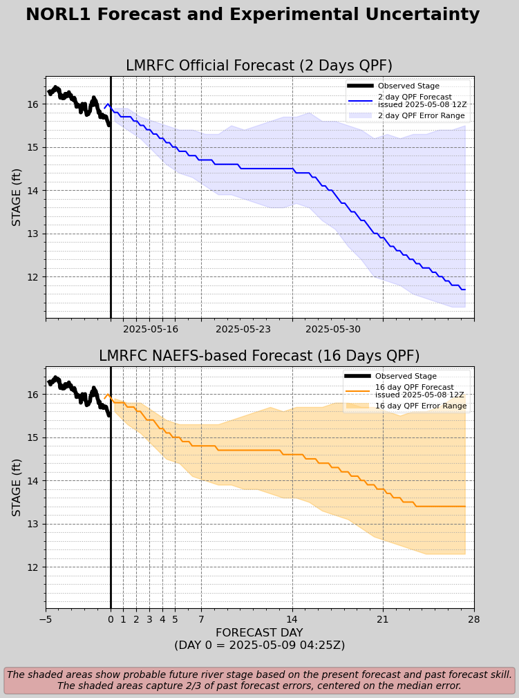
U.S. Corps of Engineers: VELOCITY READING (NEW ORLEANS) 4.2 Knots Mississippi River - Projection- Based off 48 Hours of Forecast Rainfall Mississippi River - NOLA Projection- Based off 16 Days of Forecast Rainfall (Experimental)-
Lower Mississippi River Forecast Center: Crest Forecast:
Disclaimer: For quality assurance purposes please note well that while the information contained in this website is regularly vetted for accuracy it is not intended to replace the local knowledge or expertise pertaining to port conditions of our marine operations personnel.
Access our team on the go
There are two ways to ensure you can always reach us.
Mobile App
Download our mobile app to search our corporate directory and contact us.
Print Directory
Download and print out our foldable portable directory for quick access.