Port Update
RI / Southern Massachusetts
April 03, 2025
Notices
Homeland Security Advisory System
********************************************************************************
The National Homeland Security Advisory System is at Yellow (MARSEC Level I), or an elevated level of threat for the Port of Providence
Local Time Zone
********************************************************************************
The Port of Providence and Narragansett Bay are currently utilizing Eastern Standard Time (GMT -5)
Current maximum drafts at local terminals in feet:
Current maximum drafts at local terminals in feet:
Davisville: 32-00
Provport: 38-00
Hudson: 27-06
ExxonMobil: 38-00
Shell: 40-00
Sprague Providence: 32-00 (Flood tide restricted for berthing)
Sprague East Providence: 32-06 (Daylight & flood tide restricted for berthing)
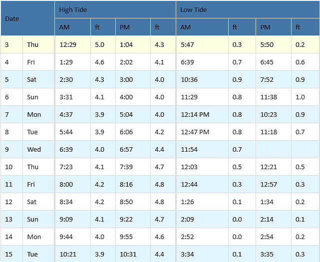
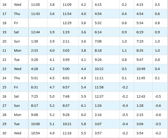
Tides / Currents
Weather / Marine Zone Forecast
Providence, RI Weather
********************************************************************************
This Afternoon: A chance of rain, mainly before 5pm. Patchy fog. Otherwise, cloudy, with a high near 62. Southwest wind around 16 mph, with gusts as high as 29 mph. Chance of precipitation is 30%.
Tonight: A chance of rain, mainly after 5am. Patchy fog before 3am. Otherwise, cloudy, with a low around 52. Southwest wind 5 to 10 mph becoming light west. Winds could gust as high as 20 mph. Chance of precipitation is 30%.
Friday: A chance of rain, mainly before 10am. Mostly cloudy, with a high near 66. Northwest wind 5 to 9 mph. Chance of precipitation is 40%.
Friday Night: Mostly cloudy, with a low around 41. Northeast wind 3 to 6 mph.
Saturday: Showers likely, mainly after 1pm. Mostly cloudy, with a high near 48. Southeast wind 6 to 9 mph. Chance of precipitation is 70%.
Saturday Night: Showers. Low around 41. Southeast wind around 6 mph. Chance of precipitation is 80%.
Sunday: A chance of showers. Mostly cloudy, with a high near 65. Southwest wind 7 to 11 mph. Chance of precipitation is 40%.
Sunday Night: Showers likely, mainly after 10pm. Mostly cloudy, with a low around 43. Southwest wind around 7 mph becoming northwest after midnight. Chance of precipitation is 70%.
Monday: A chance of showers before 2pm. Mostly cloudy, with a high near 53. North wind around 7 mph. Chance of precipitation is 50%.
Monday Night: Mostly cloudy, with a low around 36. Northwest wind 3 to 5 mph.
Tuesday: Partly sunny, with a high near 48. West wind 7 to 13 mph.
Tuesday Night: Partly cloudy, with a low around 29. West wind around 7 mph.
Wednesday: Sunny, with a high near 49. West wind 8 to 11 mph.
Wednesday Night: Mostly clear, with a low around 31. West wind 3 to 6 mph.
Thursday: Mostly sunny, with a high near 55.
Marine Forecast
********************************************************************************
Narragansett Bay:
This Afternoon: SW winds 15 to 20 kt with gusts up to 30 kt. Waves 3 to 5 ft. Patchy fog. A chance of rain. Vsby 1 nm or less.
Tonight: SW winds 10 to 15 kt, becoming W 5 to 10 kt after midnight. Gusts up to 25 kt. Waves 3 to 5 ft. Patchy fog. A chance of rain in the evening. Vsby 1 nm or less.
Fri: NW winds 5 to 10 kt. Waves 2 to 3 ft. Patchy fog in the morning. A chance of rain in the morning with vsby 1 to 3 nm.
Fri Night: NW winds 5 to 10 kt, becoming NE after midnight. Waves 2 to 3 ft.
Sat And Sat Night: SE winds 10 to 15 kt with gusts up to 20 kt. Waves 2 to 4 ft. A chance of showers in the morning, then showers.
Sun: SW winds 10 to 15 kt with gusts up to 20 kt. Waves 2 to 4 ft. A chance of showers.
Sun Night And Mon: W winds 10 to 15 kt with gusts up to 20 kt, becoming N. Waves 2 to 4 ft. Showers likely.
Mon Night: NW winds 5 to 10 kt. Waves 2 to 4 ft.
********************************************************************************
Rhode Island Sound:
This Afternoon: SW winds 20 to 25 kt with gusts up to 35 kt. Seas 5 to 7 ft. Wave detail: S 7 ft at 7 seconds and SW 1 foot at 4 seconds. Patchy fog. A chance of rain. Vsby 1 nm or less.
Tonight: SW winds 15 to 20 kt, becoming W 10 to 15 kt after midnight. Gusts up to 30 kt. Seas 5 to 7 ft. Wave detail: S 7 ft at 7 seconds and SW 1 foot at 4 seconds. Patchy dense fog. A chance of rain. Vsby 1 nm or less.
Fri: W winds 5 to 10 kt. Seas 3 to 5 ft. Wave detail: S 5 ft at 8 seconds and SE 1 foot at 13 seconds. Patchy fog in the morning. A chance of rain in the morning with vsby 1 to 3 nm.
Fri Night: NW winds 5 to 10 kt, becoming NE 10 to 15 kt after midnight. Seas 2 to 3 ft. Wave detail: SE 3 ft at 7 seconds and NE 1 foot at 2 seconds.
Sat: E winds 10 to 15 kt. Gusts up to 20 kt in the afternoon. Seas 2 to 3 ft. Wave detail: E 3 ft at 4 seconds and S 3 ft at 7 seconds. A chance of showers in the morning, then showers in the afternoon.
Sat Night: SE winds around 15 kt with gusts up to 20 kt. Seas 3 to 4 ft. Wave detail: SE 4 ft at 7 seconds and NE 1 foot at 3 seconds. Showers.
Sun: SW winds 15 to 20 kt with gusts up to 25 kt. Seas 4 to 6 ft. A chance of showers.
Sun Night And Mon: SW winds 15 to 20 kt with gusts up to 25 kt, becoming NE 10 to 15 kt. Seas 4 to 6 ft. Showers.
Mon Night: N winds 10 to 15 kt. Seas 3 to 5 ft. A chance of showers.
********************************************************************************
Buzzards Bay:
This Afternoon: SW winds 20 to 25 kt with gusts up to 30 kt. Seas 3 to 5 ft. Wave detail: S 5 ft at 5 seconds. Patchy fog. A chance of rain. Vsby 1 nm or less.
Tonight: SW winds 15 to 20 kt, becoming W 10 to 15 kt after midnight. Gusts up to 25 kt. Seas 3 to 5 ft. Wave detail: S 5 ft at 7 seconds and SW 3 ft at 4 seconds. Patchy fog. A chance of rain. Vsby 1 nm or less.
Fri: W winds 5 to 10 kt. Seas 2 to 3 ft. Wave detail: S 3 ft at 7 seconds and W 1 foot at 3 seconds. Patchy fog in the morning. A chance of rain in the morning with vsby 1 to 3 nm.
Fri Night: N winds 5 to 10 kt, becoming NE after midnight. Seas around 2 ft in the evening, then 1 foot or less. Wave detail: SW 2 ft at 7 seconds and NW 1 foot at 3 seconds, becoming N 1 foot at 3 seconds and SW 1 foot at 7 seconds.
Sat And Sat Night: S winds 10 to 15 kt with gusts up to 20 kt. Seas 2 to 3 ft. Wave detail: E 2 ft at 4 seconds and SW 2 ft at 7 seconds. A chance of showers in the morning, then showers.
Sun: SW winds 15 to 20 kt with gusts up to 25 kt. Seas 2 to 4 ft. Wave detail: S 3 ft at 5 seconds and NE 1 foot at 5 seconds. A chance of showers.
Sun Night And Mon: W winds 10 to 15 kt with gusts up to 20 kt, becoming N. Seas 2 to 4 ft. Showers likely.
Mon Night: N winds around 10 kt. Seas 2 to 3 ft.
********************************************************************************
Cape Cod Bay:
This Afternoon: SW winds around 20 kt with gusts up to 30 kt. Seas 4 to 5 ft. Wave detail: S 4 ft at 6 seconds and NE 1 foot at 5 seconds. Patchy fog. A chance of rain. Vsby 1 nm or less.
Tonight: SW winds 15 to 20 kt, becoming W 10 to 15 kt after midnight. Gusts up to 25 kt. Seas 3 to 5 ft, subsiding to 2 to 3 ft after midnight. Wave detail: S 4 ft at 6 seconds, becoming SE 3 ft at 7 seconds and W 2 ft at 3 seconds. Patchy fog. A chance of rain. Vsby 1 nm or less.
Fri: W winds 5 to 10 kt, becoming NW in the afternoon. Seas around 2 ft. Wave detail: S 2 ft at 8 seconds and W 1 foot at 3 seconds. Patchy fog in the morning. A chance of rain in the morning with vsby 1 to 3 nm.
Fri Night: N winds 5 to 10 kt. Seas around 2 ft in the evening, then 1 foot or less. Wave detail: S 2 ft at 7 seconds and N 1 foot at 3 seconds, becoming N 1 foot at 3 seconds and S 1 foot at 7 seconds.
Sat And Sat Night: SE winds 10 to 15 kt with gusts up to 20 kt. Seas 2 to 3 ft. Wave detail: SE 2 ft at 3 seconds and S 2 ft at 7 seconds. A chance of showers in the morning, then showers.
Sun Through Mon: N winds 10 to 15 kt with gusts up to 25 kt. Seas 2 to 4 ft. Wave detail: S 3 ft at 6 seconds and SW 2 ft at 3 seconds. Showers likely.
Mon Night: N winds 5 to 10 kt. Seas 2 to 3 ft.
Port / Terminal Restrictions
Cape Cod Canal Draft Restriction
********************************************************************************
The US Army Corp of Engineers has advised that the current maximum air draft for Cape Cod Canal transits remains at 135 feet. Max draft in the canal is currently 30 feet. Vessels with drafts over 28 feet will need a tide window for transit
Cape Cod Canal Transit Restriction
********************************************************************************
None at the moment
COVID 19 Guidance
********************************************************************************
COVID 19 is providing its own unique challenges, requiring all to stay extra vigilant on changing port call conditions and regulations. If you would like updates for all USA ports, the easiest method for reviewing our daily port updates is by visiting: http://ports.moranshipping.com/default.aspx
Please visit our Providence Port site at: http://ri.ports.moranshipping.com/default.aspx
Please visit our Providence Port site at: http://ri.ports.moranshipping.com/default.aspx


